Summary
General Information
Cajón del Achibueno
Country: Chile
Region: Región del Maule
Area: Río Achibueno
Nearest city: Linares
Number of journeys: 5
Total distance: 64,2km
Trail Markings: Esporádica
Trail: Claro y marcado
Route type: Ida y vuelta
Cascadas / Ríos
Flora
Lagos / Lagunas
Bosques
Panorámicas / Paisaje
Difficulty:
I did it

Hiking routes
CAJÓN DEL ACHIBUENO
Río Achibueno
Author: Camila Ponce, Tomás van Wersch
Introduction
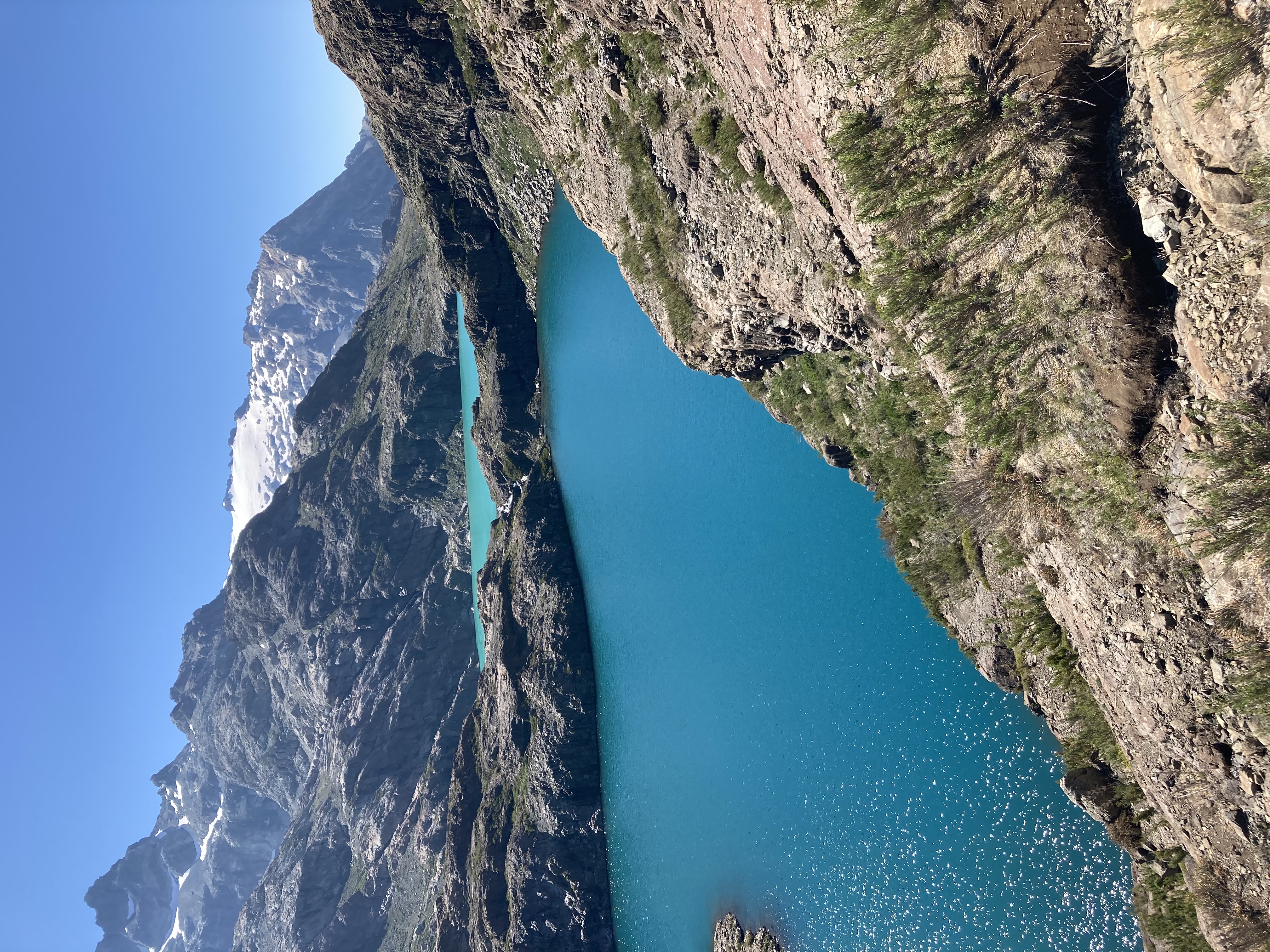
The Achibueno canyon, located in the cordillera sector of the commune of Linares, is the first “Santuario de la Naturaleza” (Nature Sanctuary) in the Maule region of Chile. The river which flows through the canyon is born from the waters of Laguna Achibueno, flowing down through the valley with the same name and edging round the skirts of the snow-capped peak Longaví. Its rivers and pools are known for their attractive green and turquoise hues, as well as for their impressive population of rainbow trout (oncorhynchus mykiss), brown trout (salmo trutta), as well as torrent duck (Merganetta armata). The flora is mainly native pre andina to andina woodland as well as temperate Valdivian rainforest and Sclerophyll scrubland.
The Nature Sanctuary is home to various endangered species including the following vulnerable species of flora: ciprés de Cordillera (austrocedrus chilensis), hualo (nothofagus glauca), huala (nothofagus leonii); and the following rare species: Chilean citronella tree (citronella mucronata), radal enano (orites mirtoidea), nirrhe (eucryphia glutinosa), the latter growing only on the river banks. A number of studies have mentioned the importance of this canyon as its flora is principally made up of deciduous species of the nothofagus genus. There is a rich variety of species as these are Sclerophyll forests with striking elements characteristic of forests from wetter zones. This combination makes for a large quantity of endemisms, i.e. a species being unique to a defined geographic location, such as rare and endangered species of tree (Benoit, 1989; Donoso, 1993). In fact, this area is a hotspot of global importance for the conservation of biodiversity (Myers et al., 2000; Arroyo et al.)
The fauna inhabiting the zone include great flocks of burrowing parrots (cyanoliseus patagonus), as well as black-chested buzzard-eagles (geranoaetus melanoleucus), condors (vultur gryphus). If you are lucky you may also glimpse the Magellanic woodpecker (campephilus magellanicus) or the chestnut-throated huet-huet (pteroptochos castaneus).
Appropriate season
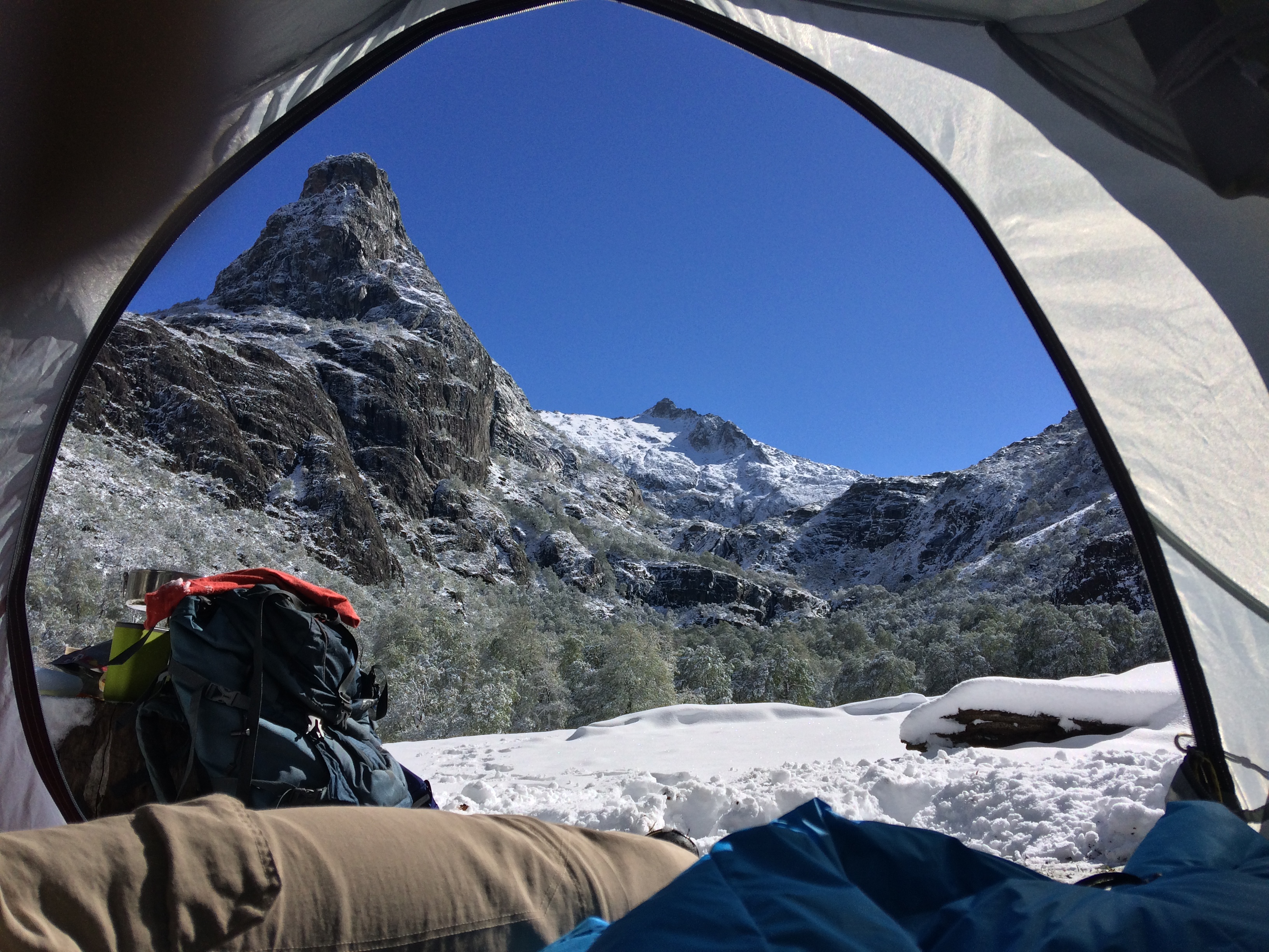
It is best to attempt this route from September to the end of May, as in winter the snow can make the trek quite difficult. That said, it is still possible to complete parts of the route during this time of year. On the other hand, in summer the temperatures can be extremely high in the valley, especially in January and February.
Access
Private Transport
From Linares, follow route L-45 towards the foothills of the Andes. Continue along this paved road, always taking the right fork leading southeast. You will cross the bridge Puente Arcos over the river Ancoa. After 12.5km the paved road ends and a well-maintained gravelled track takes its place. Follow this road until you come to the village of Pejerrey (34km) and continue to the police checkpoint (35.6km) where you may notify the police of your excursion and ask for more information about the sector. After the checkpoint there is a fork where you should go right towards Vado Azul. The road from this point is not in such good condition. After 56.6km you will come to the Fundo Punta Tricahue where you can park your car.
Public Transport
There is no public transport to the start of the route. There are, however, buses to Pejerrey which is located some 34km from Linares via route L-45.
For information regarding the timetable for buses to Pejerrey go to Linares bus terminal.
Permits / Prices
There is no permit or entry fee required for this route.
Accommodation / Facilities
Within the sanctuary there are various large areas to camp, but these are not signposted. There are no facilities at these sites, but there is easy access to rivers, streams or lakes.
Recommendations
- When you come to the police checkpoint you may notify the police of your excursion and ask for more information about the sector.
- In spring and autumn, it is sometimes be difficult to cross the rivers as the water level can rise considerably.
- It is possible to find potable water along most of the route.
Gear
- Complete trekking and camping equipment
- Trekking poles
- Waterproof clothing and gaiters (in autumn and spring)
- Warm clothing
- Sandals for river crossings
- Swimwear
Schedule
Normal Itinerary
- Linares - Bank of Río Achibueno
- Bank of Río Achibueno - Círculo Místico
- Círculo Místico - Laguna Achibueno - Círculo Místico - Laguna Añintunes - Círculo Místico
- Círculo Místico - Bank of Río Achibueno
- Bank of Río Achibueno - Linares
Alternative Itinerary
- Linares - Bank of Río Achibueno
- Bank of Río Achibueno - Círculo Místico - Laguna Achibueno - Círculo Místico
- Círculo Místico - Laguna Añintunes - Círculo Místico - Bank of Río Achibueno
- Bank of Río Achibueno - Linares


Comments
Cajón del Achibueno
Matias Barcelo 26/02/2021
Fecha expedición: 22/02/2021
Bajo las lastimas es el nombre correcto al lugar que acá le indican como "circulo mistico". Nadie en el santuario ni la gente local lo reconoce así, por lo tanto sugiero utilizar el nombre original.
Alejandro Diaz 02/03/2021
Punto alcanzado: Laguna toro , laguna Achibueno
Fecha expedición: 28/01/2021
Domingo Jara Veloso 04/03/2018
Punto alcanzado: Laguna del Achibueno
Fecha expedición: 30/01/2018
excelente ruta

Claudio Zettel 29/12/2016
Punto alcanzado: Laguna
Fecha expedición: 19/12/2016
Realizamos el tour a partir del 19 de diciembre. Nos encontramos con temperaturas súper agradables para caminar, mientras las noches todavía bien frías.

Observaciones con respecto al camino:

1. Por buena parte se puede caminar por ambos lados del Achibueno. A partir del carrito recomendamos el lado sur del Achibueno, hasta que se cruce de nuevo con el camino descrito.  Para tomar este lado cruzamos a la altura del carrito (ver descripción de la jornada 1). El carrito estaba trancado, y el árbol caído no lo encontramos. Pero un poco más arriba del carrito se puede cruzar con sandalias puestas...

2. La gente del lugar, con la cual nos encontrábamos, no conocía el "círculo místico" bajo este nombre. Lo llamaron "el animita".


Saludos!
Francisco Armijo 07/11/2016
Punto alcanzado: Laguna Achibueno
Fecha expedición: 29/10/2016
Hola!

Fui el pasado fds largo (01 Nov 2016) al Cajón del Achibueno. Les cuento:


El auto se deja al final del camino yendo desde Pejerrey.


La ruta se encuentra en buen estado, el sendero es claro la mayor parte (95%). Hay varios cruces del río, por lo que se recomienda llevar zapatillas o sandalias (el caudal igual es alto, así que hay que cruzar con precaución). Hay agua en muchas partes del sendero.


Desde el Círculo Místico se pueden visitar las dos lagunas:


1) Laguna Añintunes: sendero de 3k (ida+vuelta) toma cerca de 3h.


2) Laguna Achibueno: sendero de 5k (ida+vuelta) toma cerca de 5h.


Yo hice el sendero más las dos lagunas en 4 días, soy un correcaminos y lo hago rápido como deporte, pero recomendaría hacerlo en mínimo 5 días.


Nos nevó el día lunes y la vista fue hermosa, como estar en Narnia.


Saludos.
Juan Pablo Moraga Luarte 14/08/2021
Tracks and Waypoints
Cajón del Achibueno
Cajón del Achibueno
Colaborador: Camila Ponce
Fecha: 23/03/2016

I did it!