Summary
General Information
Los Contrabandistas
Country: Chile
Region: Región de la Araucanía
Area: Parque Nacional Conguillío
Nearest city: Curaucautín
Number of journeys: 1
Total distance: 4,04km (sólo ida)
Trail Markings: Frecuente y clara
Trail: Claro y marcado
Route type: Ida y vuelta
Fauna
Cascadas / Ríos
Flora
Bosques
Transporte público
Difficulty:
I did it

Hiking routes
LOS CONTRABANDISTAS
Parque Nacional Conguillío
Author: Juan Romero
Introduction
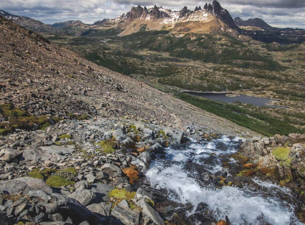
The route Los Contrabandistas is located in the Parque Nacional Conguillío, which was created on 26 May 1950 and whose name is Mapudungún, the indigenous language of the Mapuche, means “to live amongst the Araucaria trees”. This park is one of the most extraordinary places in Chile for nature lovers: with two such spectacular volcanoes as Llaima and Sierra Nevada; lakes and lagoons everywhere; huge forests full of Araucarias; a great variety of fauna amongst other attractions, this is an unmissable park for anyone who wants to visit the south of Chile.
The route is one of a series of trails within this protected area, and originally was a 15km trek starting at the information centre Centro de Informaciones Santiago Gómez Luna and ending very close to the route leading to Lonquimay in the east. However, the route has now been modified and is only 4km in length, and now starts at the information centre near to the Lake Conguillío.
Initially it was a route used by hunters and gathers from the Pehuenche tribe; years later the same track was used as a way to smuggle animals to and from Argentina and it was from this use that the trail received its name. The route is indicated by red markers and the path is clear, leading through a forest of Araucaria and Coihue and ending on the banks of the River Blanco.
This path is part of the scheme Sendero de Chile.
Appropriate season
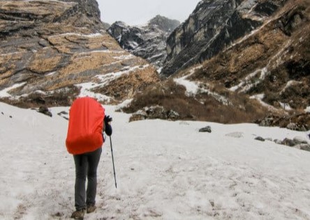
The route can be completed all year round. In winter there can be a lot of snow along the route, and access to the park can be affected at times.
Access
Parque Nacional Conguillío
Private Transport
The Parque Nacional Conguillío can be accessed from Temuco or the north from Victoria or Lautaro via the village of Curacautín. It is 84km along an asphalt road. From Curacautín to the Captrén guardpost is 34km, of which the first 10km is along another asphalt road. From Captrén it is 8km via a dirt track to the lake Lago Conguillío, which can only be transited when there is no snow. See here how to reach Parque Nacional Conguillío from Curacautín.
It is also possible to reach the park from the south, via the route Temuco – Cunco towards the village of Melipeuco (91km asphalt road), and then it is another 9km to the Truful Truful guardpost. From here drive 20km over lava plains and through forests of coihues until you come to the Araucaria forest and the lake Lago Conguillío. The road is accessible all year round, but in winter you will need to organise your access with Sendas (a private company who works with the park).
There is public transport to Melipeuco all year round – on Sundays in the summertime the transport goes as far as the park. See here how to reach the park from Melipeuco.
The other option is from the east, from Temuco via the road leading to Cajón - Vilcún - Cherquenco - Sector Los Paraguas. The road is alsphalt from Cajón to Cherquenco and then the rest is gravel. It is transitable all year round apart from when it snows, so it is recommended that you use snow chains and a 4x4 vehicle. See here how to reach Parque Nacional Conguillío.
Public Transport
There are buses run by the company Sandra Vasquez Yáñez (Curacautín Express) which offer services between Curacautín and Captrén on Mondays and Fridays departing at 6:00, 9:00, 14:00 and 18:00, and on Tuesdays and Thursdays at 6:00 and 18:00. The return from Captrén to Curacautin leaves on Mondays and Fridays at 7:00, 10:00, 15:00 and 19:00 and on Tuesdays and Thursdays at 7:00 and 19:00.
During winter the buses only go as far as the Captrén guardpost (northern entrance to Parque Nacional Conguillio), but this can also be affected by the weather.
Another option is take the bus from the Terminal Rural de Temuco (Avda. Anibal Pinto 32, Temuco), buses run by the company Nar Bus / Igillaima, towards Lago Conguillío. They depart Monday-Saturday from Temuco at 10:30, and return at 14:50. On Sundays they depart at 9:00 and return at 17:45.
The last option is to take a bus to Melipeuco or Curacautín and from there find a tourist agency or private transport to the park.
Getting to Sendero Los Contrabandistas
From the entrance at Captrén, continue along the track for 4.6km until you reach the Centro de Informaciones Santiago Gómez Luna, or you can even complete the route Los Carpinteros (6.1km) which starts at Laguna Captrén and ends where Sendero Los Contrabandista begins.
From Melipeuco, continue to the south entrance (Truful Truful), and follow the track for 29km. you will pass the lakes Laguna Verde and Laguna Arcoíris, and the Lago Conguillío. Here you will find the route to the east, alongside the Centro de Informaciones Santiago Gómez Luna.
Permits / Prices
The entry fees to the reserve are as follows:
- Peak season: Chilean adult CLP$4000 (approx. USD$8), non-Chilean adult (including non-Chilean senior citizens) CLP$6000 (approx. USD$12), disabled adult CLP$2000 (approx. USD$4), Chilean child under 6 years old free, Chilean child between 6 and 18 years old CLP$2000 (approx. USD$4), non-Chilean CLP$3000 (approx. USD$6), disabled child free, and Chilean senior citizen (60 years or older) CLP$2000 (approx. USD$4).
- Low season: Chilean adult CLP$2000 (approx. USD$4), non-Chilean adult (including non-Chilean senior citizens) CLP$6000 (approx. USD$12), disabled adult CLP$1000 (approx. USD$2), Chilean child under 6 years old free, Chilean child between 6 and 18 years old CLP$1000 (approx. USD$2), non-Chilean CLP$1500 (approx. USD$3), disabled child free, and Chilean senior citizen (60 years or older) CLP$1000 (approx. USD$2).
Peak season is from November to March and Low season is from April to October.
Accommodation / Facilities
In the Parque Nacional Conguillío there are various campsites which are currently run by the company Sendas. There are also cabins to rent in the park which are run by the same company.
On the main beach by Lago Conguillío there is a café and a shop with basic products (fresh bread, groceries, juice, wine and beer). It is open every day during Peak season.
Another option is to stay in the La Baita cabins which are just outside the park near to the south entrance. At km18 towards Laguna Verde. It also has a restaurant.
Recommendations
- There is only drinking water available at the end of the route at the river Estero Blanco.
Gear
- Water bottle to fill up along the route
- Snack
- Trekking poles (optional)
- Hat
- Sun protection
- Trekking boots
Schedule
- Curacautín or Melipeuco - Sendero Los Contrabandistas - Curacautín or Melipeuco
-

Juan Cristóbal Hurtado - Volcano Llaima from the trail Los Contrabandistas
-

Juan Cristóbal Hurtado - Start of the route
-

Juan Cristóbal Hurtado - First part of the route
-

Juan Cristóbal Hurtado - First part of the forest
-

Juan Cristóbal Hurtado - Volcano Llaima from the trail Los Contrabandistas
-

Juan Cristóbal Hurtado - Descent to the plain
-

Juan Cristóbal Hurtado - View of the plain
-

Juan Cristóbal Hurtado - Forest of Coihues
-

Juan Cristóbal Hurtado - Forest of Coihues
-

Juan Cristóbal Hurtado - Sign marking the end of the route
-

Juan Cristóbal Hurtado - Estero Blanco


Comments
Los Contrabandistas
Juan Cristóbal Hurtado 28/03/2016
Punto alcanzado: Estero Blanco
Fecha expedición: 18/02/2016
Bonita ruta, dan ganas de seguir mas allá del Estero Blanco.
Tracks and Waypoints
Los Contrabandistas
Los Contrabandistas
Colaborador: Juan Romero
Fecha: 29/03/2016
Para agregar al GPS
Colaborador: Juan Romero
Fecha: 28/12/2015

I did it!