Summary
General Information
Campamento De Agostini, Monte San Lorenzo
Country: Chile
Region: Región de Aysén
Area: Monte San Lorenzo
Nearest city: Cochrane
Number of journeys: 3
Total distance: 36km
Trail Markings: Esporádica
Trail: Claro y marcado
Route type: Ida y vuelta
Fauna
Glaciares
Cascadas / Ríos
Flora
Lagos / Lagunas
Bosques
Panorámicas / Paisaje
Transporte público
Difficulty:
I did it

Hiking routes
CAMPAMENTO DE AGOSTINI, MONTE SAN LORENZO
Monte San Lorenzo
Author: Joaquín Prado, José Mena
Introduction
The route to the campsite Campamento De Agostini is approximately 36km there and back, and is located to the route of the town of Cochrane, specifically in San Lorenzo estate. This route is of moderate difficulty and can be completed by a wide range of people who like hiking, mountains and multiple day excursions.
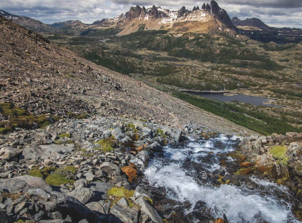
Campamento De Agostini is an excellent reason to explore one of the most beautiful regions of Patagonia. Found on the northern face of Mount San Lorenzo or Cochrane, which at 3706m is the second highest summit in Patagonia, it offers countless surprises to those who dare to climb it.
The campsite was named after the famous priest Father Alberto María De Agostini who loved Chilean and Argentinian Patagonia and who began exploring the valleys surrounding Mount San Lorenzo in 1940. He then established this places as his base camp when he finally – after three failed attempts – reached the main summit on the 12th of December, 1943. It is not a surprise that Father De Agostini marvelled at this Patagonian landscapes, as those who make it as far as this valley will find themselves in the most intimate environment of southern beauty: the isolation; the dramatic flora with its dense forests of Lenga and Ñirre trees; the varied fauna, with the possibility of glimpsing huemules, armadillos, foxes, and if you are really lucky the timid but respected Patagonian “lion”; and of course the enormous glaciers which overlook the region.
Appropriate season
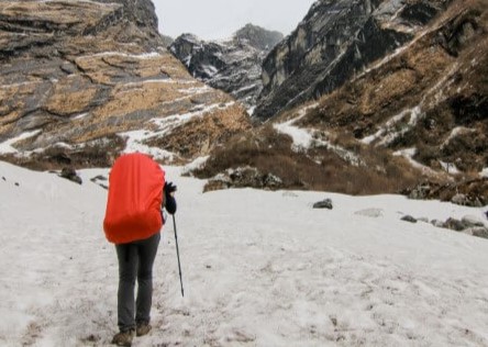
Even though it is possible to reach Campamento De Agostini all year round, the best period is between October and April due to the warmer temperatures and clearer access. In winter the route becomes more difficult due to the snow and the low temperatures.
Access
The closest town to this route is Cochrane. See here how to reach Cochrane.
Cochrane – Valle río Tranquilo
Private Transport
From Cochrane, follow route 7 (Carretera Austral) heading south towards the village of Caleta Tortel. After having driven approx. 4km you will reach a fork in the road. Here you should take the turning to the east (left of the road) towards San Lorenzo (indicated by a sign), and continue on the eastern shore of the lake Laguna Esmeralda and then through a beautiful Patagonian landscape. After continuing for another 32km, heading deeper into the valley Valle del río El Salto, you will reach a second turning. Follow the road leading east (left) which takes you through the Valle del río Tranquilo towards the sector of the Olivieo Paillacar estate. After driving for 13km from the second turning, and having crossed a couple of bridges, you will reach a sector known as “Lunco”, where there is another turning. Here the road to the right (south) leads to San Lorenzo (there is a small sign indicating this) See photo 1. In this area you will be able to see Mount San Lorenzo to the southeast for the first time. Even though it is possible to continue for a few more metres by car from the last turning, we recommend that you leave your vehicle here as there is enough space to park it without blocking the road. It is approx. 50km to this point from Cochrane along a gravelled road in good condition. It should take approx. 1h-1½h to the parking point from Cochrane.
Public Transport
From Cochrane there is a bus route up to the bridge Puente San Lorenzo, on the way to Lake Brown. The buses leave on Mondays and Thursdays at 11:00am from Cochrane and returning at 12:30pm. The bus tickets cost CLP$1800 (USD$4) per person (September 2015).
In this case you should get off in the sector called “Lunco”, which is where there is a turning to Lake Brown on one side and on the other there is a route to the estate and Mount San Lorenzo on the other (there is a small sign indicating this) See photo 1. In this area you will be able to see Mount San Lorenzo to the southeast for the first time. Here you should start the hike along the road on the right hand side, towards the south. This is the same point where the route begins for those who travel via private transport.
For more information about bus routes, contact Marcial Moya (+56 9 87464742).
Permits / Prices
There are no permits or entrance fees to complete this route.
Accommodation / Facilities
- In the San Lorenzo estate, property of Luis Soto de la Cruz, there is a well-equipped campsite with good facilities: there is a large space to camp, a spacious dining area, toilets and hot water showers.
- In the campsite Campamento De Agostini, you can either camp or stay in the impeccable Tony Rohrer refuge.
*In 2015, prices are CLP$3000 (USD$6) per person for both camping and the refuge.
Recommendations
- From the campsite at Luis Soto’s house there are a range of hiking routes leading into other valleys. Be sure to give yourself enough time for the route when you are planning as this is a good option.
Gear
- Trekking boots or high-ankle boots.
- Comfortable clothing, windbreaker and hat, gloves, etc. to keep warm.
- Sun-glasses, sun protection.
- Trekking poles (optional).
Schedule
Itinerary 1:
- Cochrane – Fundo San Lorenzo (casa Luis Soto)
- Fundo San Lorenzo – Campamento Agostini
- Campamento Agostini – Cochrane
Itinerary 2:
- Cochrane – Fundo San Lorenzo
- Fundo San Lorenzo – Campamento Agostini – Fundo San Lorenzo
- Fundo San Lorenzo – Cochrane


Comments
Campamento De Agostini, Monte San Lorenzo
Joaquín Prado 04/10/2015
Punto alcanzado: Laguna San Lorenzo
Fecha expedición: 03/03/2015
La ruta al campamento De Agostini es una muy bonita ruta, de fácil acceso que permite internarse en lo más intimo de la montaña y soledad patagónica. Sencilla y con paisajes sobrecogedores. La recomiendo 100% para todos los que visiten la zona. Además este sector cuenta con la posibilidad de realizar varios senderos más (no descritos en esta ruta), pero posible para todos a quienes les guste explorar.
Tracks and Waypoints
Campamento De Agostini, Monte San Lorenzo
Track completo Ruta Campamento De Agostini
Colaborador: Joaquín Prado
Fecha: 10/09/2015

I did it!