Summary
General Information
Parque Nacional Radal Siete Tazas
Chiquillanes
Country: Chile
Region: Región del Maule
Area: Parque Nacional Radal Siete Tazas
Nearest city: Molina
Number of journeys: 1
Total distance: 7,9km
Trail Markings: Frecuente y clara
Trail: Claro y marcado
Route type: Circuito
Fauna
Flora
Bosques
Panorámicas / Paisaje
Difficulty:
I did it

Hiking routes
CHIQUILLANES
Parque Nacional Radal Siete Tazas
Author: Mario Arias
Introduction
The Parque Nacional Radal Siete Tazas is located in the commune of Molina, in the Maule region, and is one of the most well-known protected areas in Chile. Named as a national reserve in 1996, it was then made into a national park in 2008 with an aim to protect and conserve the species of flora and fauna native to this zone of the country.
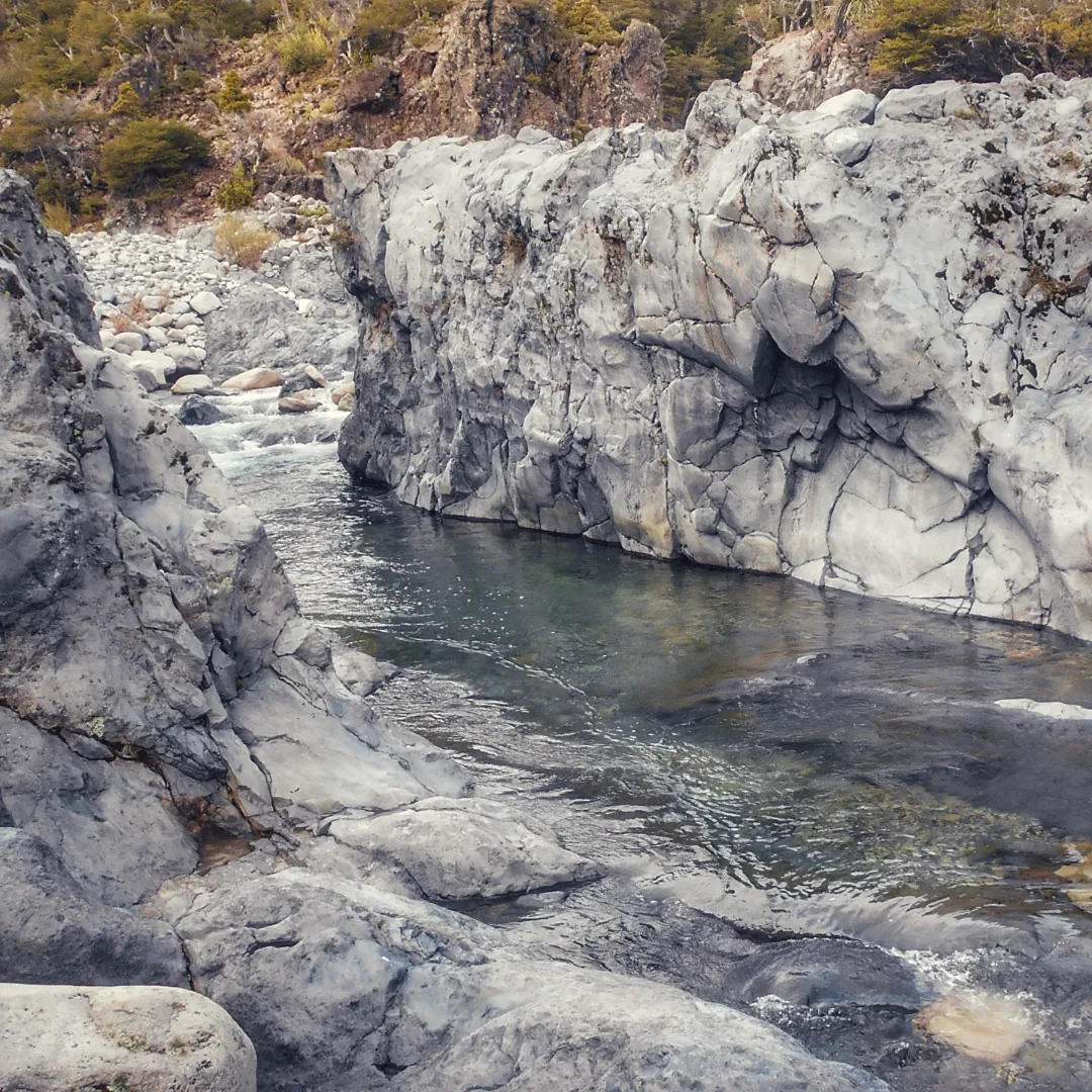
Its main attraction is the crystalline waters of the River Claro, which over the years have sculpted and given form to the basalt rock which has been deposited there by various volcanic eruptions. This has produced irregular waterfalls and beautiful pools which, surrounded by indigenous vegetation, produce stunning postcard-like surroundings.
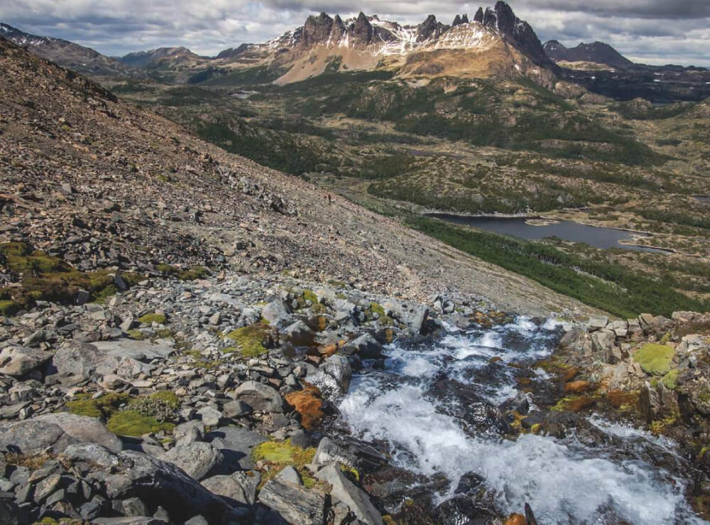
The principal reason why people visit the Chiquillanes trail is for its wide range of landscapes it covers, and the various natural viewpoints along the way from where you will have stunning views of the Valle del Río Claro and the volcano Descabezado Grande. As well as being aesthetically pleasing the trail visits a number of interesting ecosystems: schleophyll forest, deciduous forest and high Andean steppe. The route is named after the indigenous nomadic people who once lived in the mountainous region of central Chile, as the trail follows some of their ancient travelling routes.
Appropriate season
The Parque Nacional Radal Siete Tazas is open all year round, so the routes can be completed during any season. Be in mind that during autumn and winter, rainfall is relatively heavy and the temperature drops.
Access
The closest town to the park is Molina. See here how to reach Molina.
Molina - Parque Nacional Radal Siete Tazas
Private Transport
From the town of Molina, approx. 212km to the south of Santiago, follow route K-175 heading southeast leading to the town of Radal. After approx. 27km there is a turning south (right), and the signpost shows that this is the way to the park. From this point onwards the road is gravelled. Follow this road (K-275) for approx. 20km until reaching the viewpoint over the waterfall Velo de La Novia; following this route approx. 3km to the south you will arrive at the guardpost of the sector Siete Tazas, which is also the starting point for the routes Siete Tazas and Salto La Leona. It should take 1-1½h from Molina.
Public Transport
From Molina, approx. 52km to the north of Talca, there are two bus companies (buses Hernández and buses Radal Siete Tazas) which depart from the Bus Terminal in Molina and take passengers to the park. During the summer the buses run more frequently and in winter they depart just once a day. Furthermore, in summer there are daily buses from Curicó.
Permits / Prices
The park is open all year round. In summer it opens at 8:30 and closes at 20:00; in winter it opens at 9:00 and closes at 17:30. The entry fees to the park are as follows: Chilean adult CLP$2000 (approx. US$4), foreign adult CLP$4000 (approx. US$8), Chilean and foreign children CLP$600 (approx. US$1).
Accommodation / Facilities
Nearby the guard post there are toilets and picnic areas, whilst in the zone Parque Inglés you will find campsites and hostels. In the sector Radal you can get medical assistance at the first aid post, approx. 11km from the zone Parque Inglés.
Recommendations
- Pets are not allowed in the park.
- The route is not recommended for elderly people or very small children due to the moderate to steep gradient along much of the route.
Gear
- Trekking boots or high-ankle boots
- Water bottle
- Sun hat
- Sun-glasses, sun protection
- Trekking poles
Schedule
Normal Itinerary
- Molina – Chiquillanes Trail – Molina
Alternative Itinerary
- Molina – Velo de la Novia - Salto La Leona - Siete Tazas – Chiquillanes Trail – Molina


Comments
Chiquillanes
Mario Arias 31/07/2015
Punto alcanzado: Ruta completa
Fecha expedición: 13/06/2015
Sendero que cuenta con grandiosas vistas panorámicas hacia bosques de robles y que es una buena alternativa para complementar el concurrido sendero El Bolsón en el mismo Parque Nacional.
Tracks and Waypoints
Chiquillanes
Sendero Chiquillanes
Colaborador: Álvaro Vivanco
Fecha: 17/08/2015
Ruta completa que conecta con el sendero El Bolsón.

I did it!