Ruta de trekking Piedra del Águila
Región de los Lagos, Futaleufú


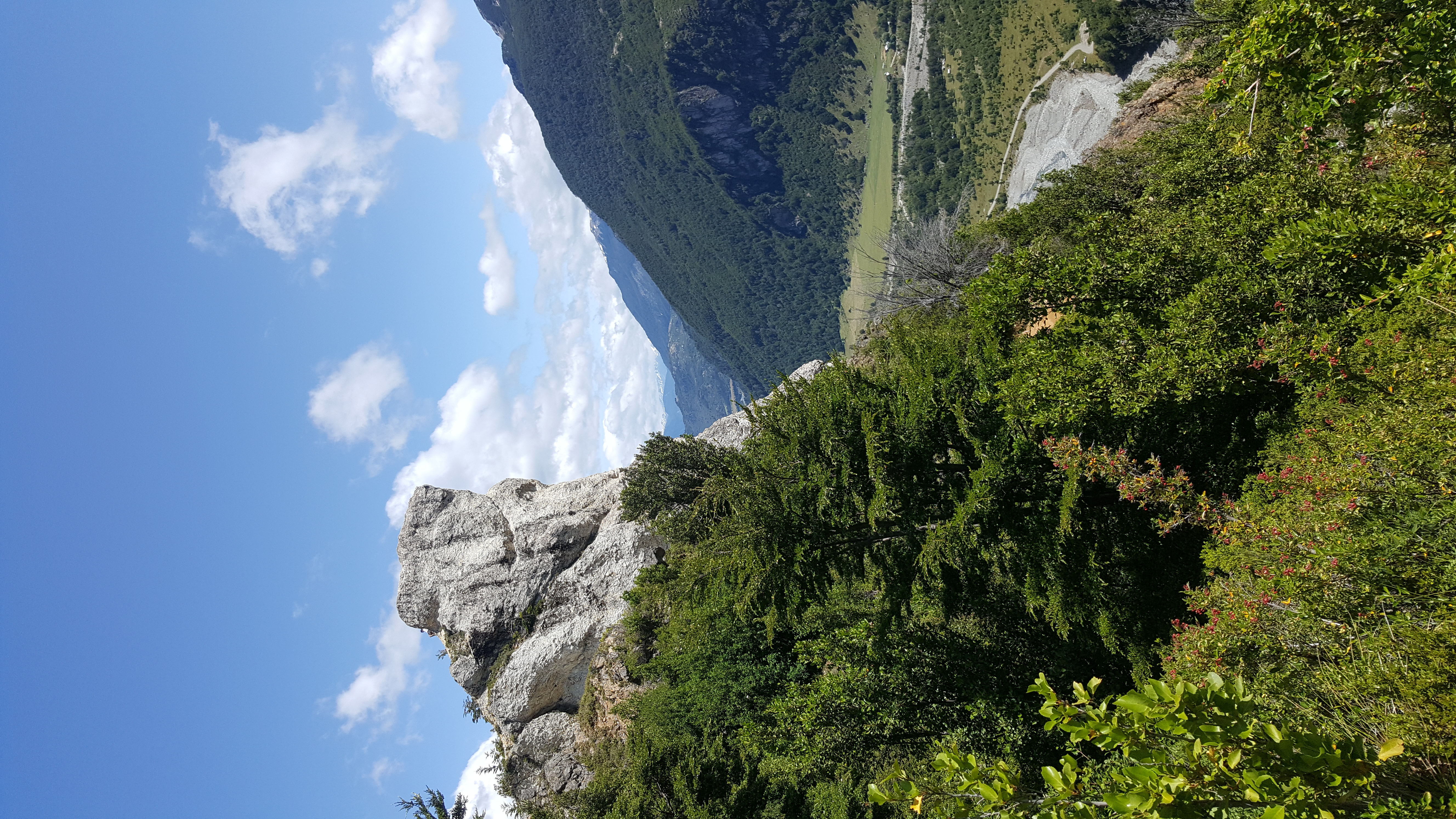
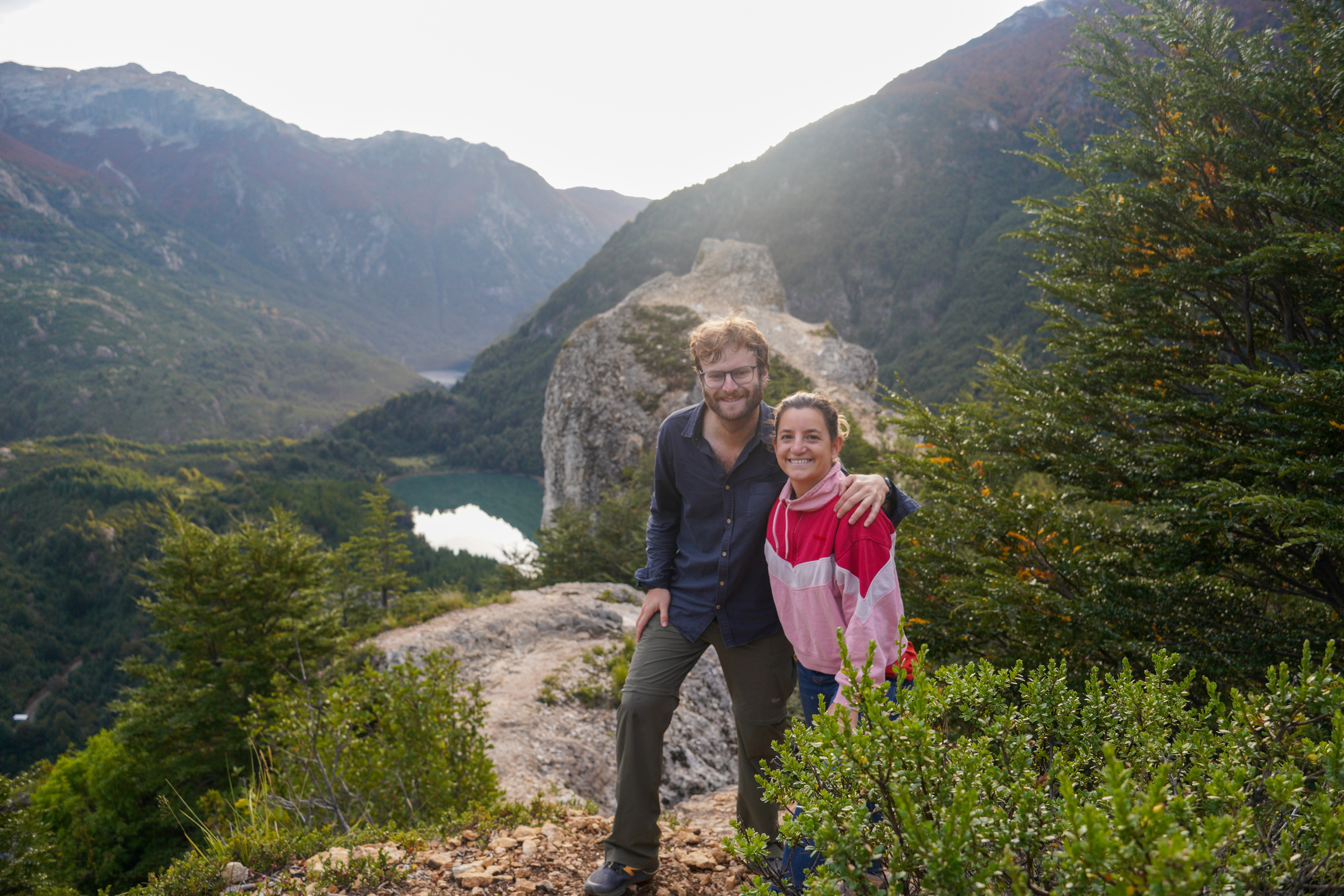
El sendero Piedra del Águila es uno de los senderos clásico del pueblo de Futaleufú. Distante a aprox. 4,5km desde la plaza de armas de esta localidad hasta su inicio, esta ruta se presenta como una excelente opción para la práctica de senderismo. Durante su recorrido se tendrán amplias vistas del valle del río Espolón, de hermosos lagos como el Pinto y Noroeste, así también de numerosas cumbres que se alzan en el horizonte, destacando la vista hacia el cerro Tres Monjas, ícono de este sector de la Patagonia chilena.
La Piedra del Águila es una gran roca de cerca de 40m de altura, compuesta por material conglomerado blanquecino que sin duda alguna destaca desde las lejanías. Es visitada diariamente por numerosos visitantes, ya sea por su cercanía desde Futaleufú, condición que permite aproximarse a pie desde la ciudad si es que no se tiene locomoción propia, como también por ser un sendero de baja dificultad y que en 1h a 1½h de caminata conduce a este excelente mirador patagónico.
Futaleufú es un pueblo fronterizo, y actualmente, un polo turístico en el sector norte de la Patagonia chilena. Su historia se remonta al año 1912, cuando una familia proveniente de isla de Chiloé, encabezada por don Celerino Moraga, se instaló en este sector recóndito y hasta entonces inhabitado de Chile. Durante la década de los 20’ seguirían llegando más familias al sector, creándose finalmente el pueblo.
La palabra Futaleufú en lengua indígena significa "río grande" o "grandes aguas", haciendo clara alusión al torrentoso río Palena.
Todo el año.
Santiago – Futaleufú
Para acceder al pueblo de Futaleufú existen múltiples opciones, siendo las más comunes las que se pasan a detallar a continuación:
- Vía marítima: Desde Santiago dirigirse vía aérea o terrestre hasta Puerto Montt, ciudad desde la cual es posible tomar una embarcación hasta Chaitén. Una vez en esta se deberá continuar hacia el sureste por la Carretera Austral por ~150km hasta arribar a Futaleufú. Este tramo puede ser cubierto por transporte público (buses Cardenas y Cumbres Nevadas).
- Una segunda opción es trasladarse vía terrestre desde Santiago a Puerto Montt, y desde allí, a través de la carretera Austral, hasta Futaleufú, o bien, y más recomendable, cruzar hacia Argentina a la altura de la ciudad de Osorno vía paso Cardenal Samoré y reingresar a Chile por el paso Futaleufú hasta el pueblo homónimo.
Para ver más opciones de acceso se recomienda visitar el sitio web de la Municipalidad de Futaleufú.
Futaleufú – Piedra del Águila
Desde la plaza del pueblo de Futaleufú dirigirse hacia el oeste a través de la calle Pedro Aguirre Cerda. Al final de esta última comienza un camino de tierra que bordea el río Espolón por su ribera norte. Seguir por este por un poco más de 1.5km hasta cruzar un puente. Unos ~150m luego del puente se abre un desvío hacia el noroeste (derecha) que marca el camino hacia la Piedra del Águila y que está debidamente señalizado. Tomar este desvío y continuar por ~1.2km hasta llegar a segundo desvío que se abre hacia el norte (derecha) y que también se encuentra indicado. Seguir por este desvío por ~150m hasta cruzar un segundo puente que es bastante rudimentario. A ~150m del cruce se debe tomar un tercer desvío que se abre hacia el noroeste (izquierda). Seguir por este camino por 500m hasta llegar a una amplia explanada que permite estacionar el vehículo. En este punto comienza el sendero.
Esta ruta no requiere permisos ni pago de tarifas para su recorrido.
Inexistente.
- No hay donde abastecerse de agua durante la ruta.
- Si no se tiene vehículo propio, se puede caminar todo el camino de acceso. Para este tramo considerar 1h a 1½h adicionales desde la plaza de Futaleufú (sólo de ida).
- El pueblo de Futaleufú cuenta con una completa oferta de alojamiento y servicios turísticos.
- Zapatos de trekking o caña alta.
- Ropa cómoda, cortaviento y un poco de abrigo (gorro, guantes, etc.).
- Lentes de sol, protección solar.
- Bastones (opcional).
- Futaleufú - Piedra del Águila - Futaleufú
 Muy buen paseo! Nos demoramos 2 horas en subir y volver al auto, considerando unos 45 minutos de subida.