Summary
General Information
Monumento Natural Cueva del Milodón
Mirador Cueva del Milodón
Country: Chile
Region: Región de Magallanes
Area: Monumento Natural Cueva del Milodón
Nearest city: Puerto Natales
Number of journeys: 1
Total distance: 1,1km (ida y vuelta)
Trail Markings: Frecuente y clara
Trail: Claro y marcado
Route type: Ida y vuelta
Fauna
Flora
Bosques
Panorámicas / Paisaje
Señal de celular
Apto para niños menores de 10 años
Paleontología / Fósiles
Difficulty:
I did it

Hiking routes
MIRADOR CUEVA DEL MILODÓN
Monumento Natural Cueva del Milodón
Author: Catalina Polloni (CL).
Introduction
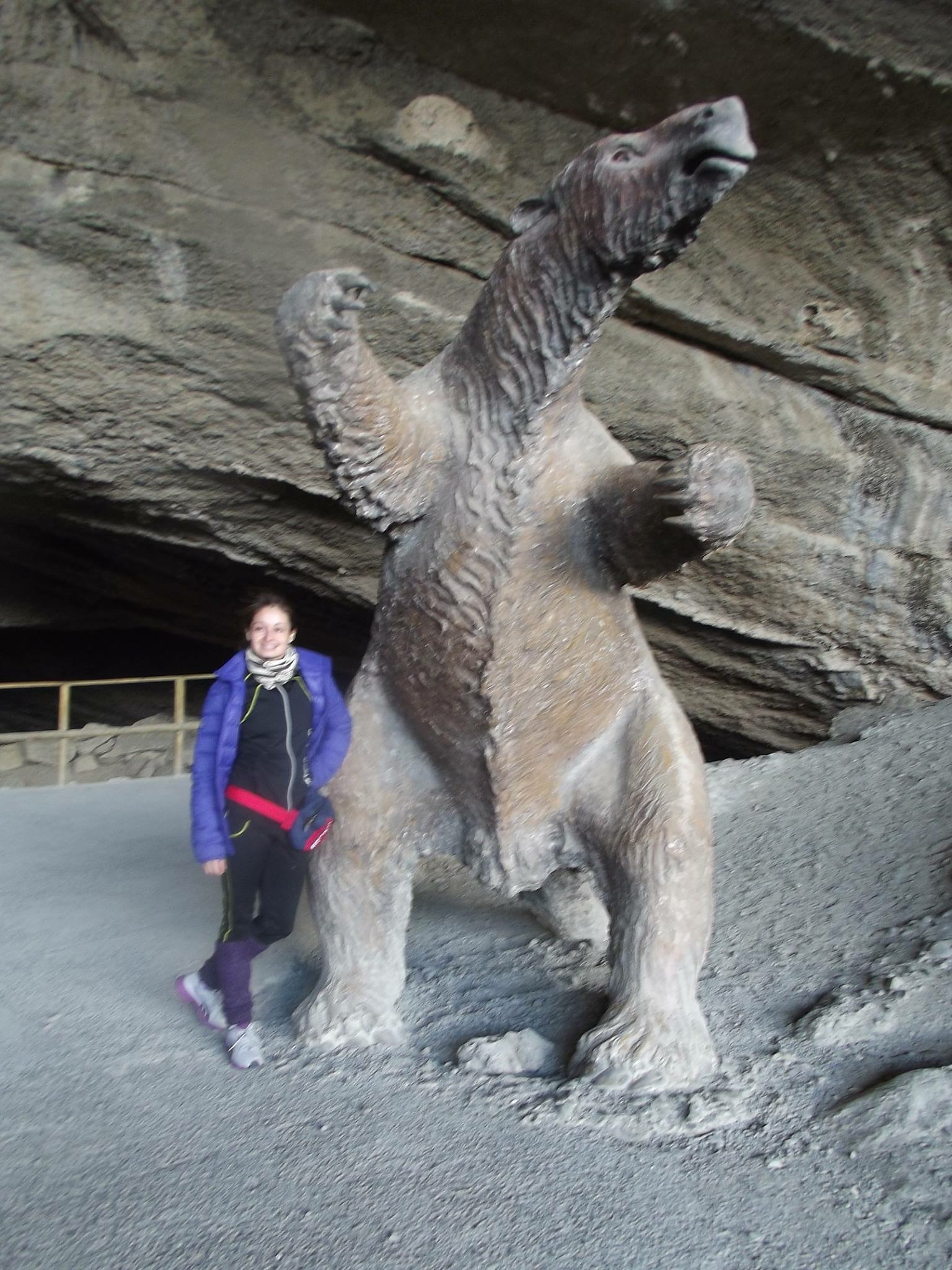
The route Mirador Cueva del Milodón (Mylodon Cave Viewpoint) is located in the national park Monumento Natural Cueva del Milodón (later referred to as MNCM), some 26km from the city of Puerto Natales. The MNCM was established on 2nd January 1968 at the request of the Consejo de Monumentos Nacionales (Chilean National Monuments Counsel) due to it being an important paleontological site. The park’s main attraction is the caves where remains of prehistoric animals have been found, these being different species and sizes, the largest of which are known as “megafauna”. One of the species found in the cave was the Mylodon (Mylodon darwini), which is described as a “large mammal which lived in this zone between 14500 and 10000 years ago. An ancient ancestor to the sloth, the Mylodon walked on four legs, was about two metres in length from head to tail, weighed around a tonne and was covered in long, thick fur.”
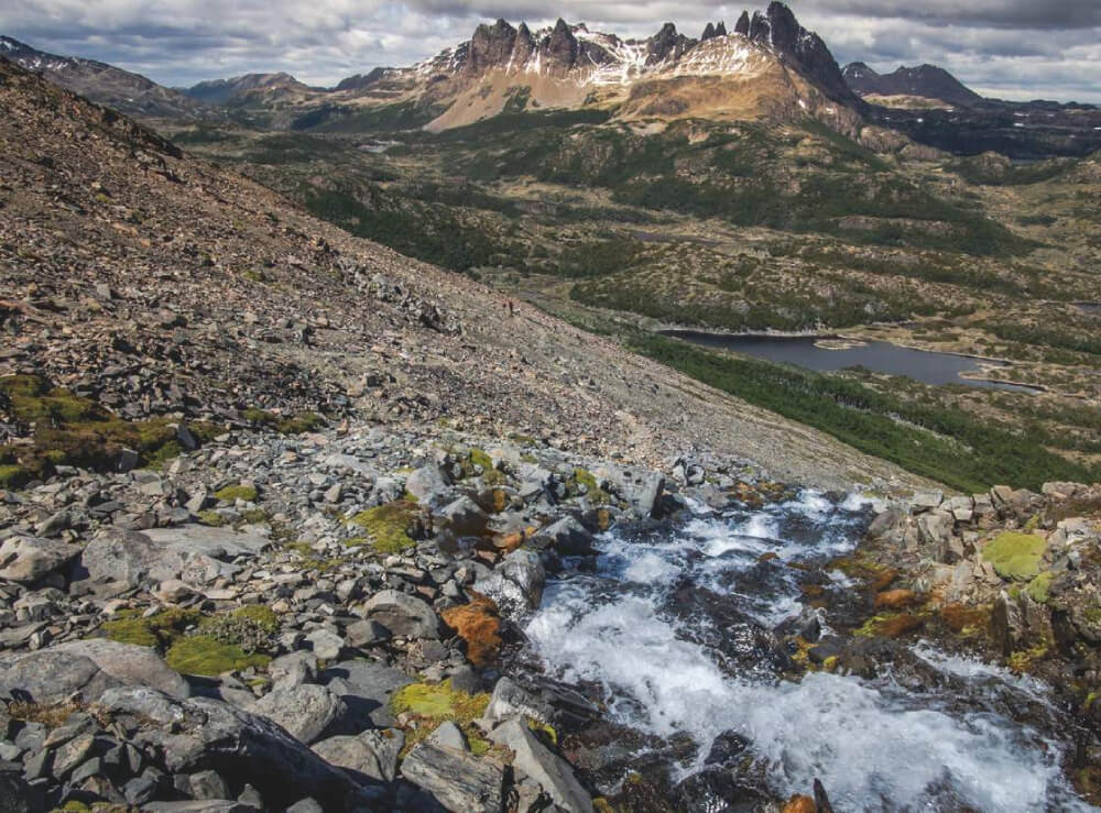
Within the MNCM park, there are a number of routes that will take you to the Cueva Grande (Big Cave), the Cueva del Medio (Middle Cave), the Cueva Chica (Small Cave) and the Cueva Silla del Diablo (The Devil’s Chair Cave), these all being important geographical and paleontological sites in the area. The route Mirador leads to a panoramic viewpoint of the park and of geomorphological evidence of the dried-out paleolake. This lake was formed when the glaciers started to retreat, after growing to their greatest size some 50,000 years ago.
This route is 525m in distance and takes around 45 minutes to complete, taking into account stops made as part of a tour, with information regarding the area’s wildlife. The route begins at the visitors’ centre, where you will start by ascending 134 metres along a rocky road though Lenga and Ñirre trees, both of which are native Southern Chile and protect you from the notorious Patagonian wind. Once you reach the viewpoint you will be able to see the post-glacier landscape and feel the cold wind coming from the nearby Southern Patagonian Ice Field. Here there is also interactive information on the form of the land.
References
Cueva del Milodón. Conaf.
Appropriate season
All year round but take care on very windy days.
Access
Punta Arenas - Puerto Natales
From Punta Arenas (km0), the capital of the Magellan region and Antártica Chilena Province, take route 9 (a paved road) towards the city of Puerto Natales. This road heads north, passing by the airport Presidente Ibáñez (turn-off at km14). At km54 you will reach the sector Cabeza de Mar (a group of saltwater lakes) where there is a fork in the road: the road that heads north-east (right) is route 255 which leads to the pass Paso Integración Austral which acts as a border between Argentina and Chile (also known as Monte Aymond); and the road that continues north-west (left) is the one you should take as it goes to Puerto Natales. Route 9 continues through the vast pampa plains that are so characteristic of Eastern Patagonia and passes Villa Tehuelches (km100, services available), the Monumento Natural Morro Chico (km146), the river Río Rubens (km179; hotel) and the turn-off to Dorotea border pass Dorotea (km233). Once you reach km237, just 5m before Puerto Natales, there is a bypass heading north (right; signposted) that will allow you to avoid the town and carry on straight to the national park, Parque Nacional Torres del Paine. The journey from Punta Arenas to the bypass takes about 2 to 3 hours.
If you need petrol, provisions or just a rest, we recommend that you continue along the road to Puerto Natales. This town is the capital of the Última Esperanza Province, and was founded in 1911 as the port of exit of the livestock industry in the sector. Even though it is small and a little more expensive than Punta Arenas, it has everything necessary to organise an excursion to the park. From Punta Arenas to Puerto Natales is approx. 242km.
Public Transport
From Punta Arenas, take a bus to Puerto Natales (approx. 3 hours). Campanies that provide such a service include Buses Fernandez, BusSur and Buses Pacheco. The prices vary between CLP$5000 (~USD$10) y CLP$7000 (~USD$14). If you ask the company beforehand, the buses can also stop at Punta Arenas airport to drop off or pick up passengers. Some companies allow you to buy tickets on the Internet. Buses arrive at the road transport terminal in Puerto Natales.
The return trip to Punta Arenas departs from the same road transport terminal.
Puerto Natales - M.N Cueva del Milodón
From Puerto Natales (km0) take the coastal road out of the city to continue along route 9 once again. At km16, take the turn-off to the west (left, sign-posted), which leads to the Monumento Natural Cueva del Milodón. Continue along route Y-290 for about 9km until you arrive at this protected area’s car park and gate, which is to the right (north). From Puerto Natales to this last point should take about 30 minutes.
Public Transport
- Taxi: in the square in Puerto Natales you will find taxis that will take you to the MNCM and wait for an hour whilst you explore the area. Radiotaxi Milodón offers this service for CLP$20000 (~US$ 40)
- Bicycle: you can rent bikes in the square in Puerto Natales, and the route is the same as mentioned above for cars. The route takes around 2 hours if going by bike. Beware of strong winds and cars.
- Guided tour: many companies offer short visits as part of tour packages for the park Nacional Torres del Paine. Ask the agencies in Puerto Natales.
Permits / Prices
The Monumento Natural Cueva del Milodón is open everyday all year round from 8:00 to 19:00 during peak season (October to April) and from 8:30 to 18:00 during low season (May to September). The prices for peak season entry are: Non-Chilean adult CLP$4000 (~US$ 8), Chilean adult CLP$2000 (~US$ 4) children CLP$500 (~US$ 1). In low season the costs are: Non-Chilean adult CLP$2000 (~US$ 4), Chilean adult CLP$1000 (~US$ 2) and children free entry.
Accommodation / Facilities
At the entrance of the Monumento Natural Cueva del Milodón there are toilets, a visitors’ centre, a café and a restaurant. There are no authorised areas to camp, but there are picnic areas.
Recommendations
- We recommend that you also complete the Caves circuit as well as this route. It is well worth it to take your time and understand the paleontological and geographical value of the park.
- The Monumento Natural Cueva del Milodón has a path that is 350m long and designed for those with physical disabilities.
- There is a bike rack in front of the gates so you can leave your bike there securely whilst you explore the park.
Gear
- Trekking boots or boots with a high ankle.
- Comfortable clothes, windjacket, and hat, gloves etc. to guard against the cold.
- Sunglasses, sun protection.
- Trekking poles (optional).
Schedule
- Puerto Natales - Monumento Natural Cueva del Milodón - Puerto Natales


Comments
Mirador Cueva del Milodón
Catalina Polloni 10/04/2015
Punto alcanzado: 236msnm
Fecha expedición: 20/03/2015
Un buen sendero para disfrutar, bastante bien marcado y accesible. A pesar de la pendiente hacia el mirador su corta distancia permite subirlo con calma para alcanzar buenas vistas sobre el área. Interesantes infografías de Conaf, vegetación nativa e historia paleontológica en el sector. recomendado!
Tomás Oyarzún Montes 01/05/2015
Punto alcanzado: 236msnm
Fecha expedición: 20/03/2015
Gran sendero, muy informativo y con hermosas vistas. Geología, geografía y paleontología junta en un solo lugar.


Un placer visitar el Monumento en general, tomese el tiempo y aplane sus interesantes senderos.


Totalmente recomendable!
Melany Cabrera 27/01/2016
Punto alcanzado: A
Fecha expedición: 23/03/2014
Muy lindo, además aprendes mucho

I did it!