Summary
General Information
Corte San Carlos
Country: Chile
Region: Región de Aysén
Area: Los Ñadis
Nearest city: Cochrane
Number of journeys: 1
Total distance: 21km
Trail Markings: Inexistente
Trail: Poco marcado y/o intermitente
Route type: Ida y vuelta
Cascadas / Ríos
Arqueología / Historia
Panorámicas / Paisaje
Difficulty:
I did it

Hiking routes
CORTE SAN CARLOS
Los Ñadis
Author: José Mena (CL).
Introduction
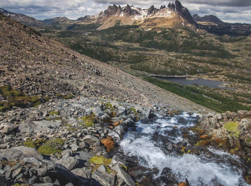
The oldest path in Aysén
The route towards Corte San Carlos guards one of the best kept secrets of Aysén, and more specifically, of the basin of the river Baker. Whoever ventures through these lands receives a generous reward: firstly, this route is the most accessible way to see the Saltón del Baker, an important rapid in the river of which you will have an unbeatable view See photo 10. The so called “Saltón” is an area where there is an abrupt narrowing of the Baker’s riverbed and where the greatest river in Chile acquires an impressive strength and speed. However, the greatest reward is found a little further on, when the path finally climbs through one of the gorges that enclose the giant river Baker to the south, and leads through an incredible semi-tunnel that split the parent rock, some 645m long and more than 100m above the level of the river. This is the Corte San Carlos See photo 11, also known as Paso Lucas Bridges; a rustic but impressive feat of engineering that was constructed in 1902 by order of the Chilean government, and which made it possible for goods and livestock to be transported from the farms to the open sea. Due to the difficult geography of the region left the pioneers no alternative but to advance straight through a sheer wall of granite with little more than shovels and pickaxes. Without a doubt, the adventure of reaching the heights of this old pass introduces a certain excitement to the route.
Along with being a very beautiful route (bordering on the south-eastern border of the Parque Nacional Laguna San Rafael), another merit is its value in terms of national heritage and history: when you follow this old trade route you are bearing witness to a pioneering past that is uniquely obvious in somewhere like Patagonia. With good reason, this site was declared a National Historic Monument in 2009. As the path follows close to the river Baker for a number of kilometres, as well as crossing over various pieces of land belonging to the local Gauchos, it is likely that you will get the feeling of going deep into a genuine Patagonian community that hides silently in these areas, often almost invisible when you simply follow the Carretera Austral, or visit the more well-known touristic destinations.
It takes a whole day to complete the route that leads to Corte San Carlos, but as it has little inclination and you need not carry too much it is not very physically demanding, so it is a suitable option for people of varying abilities and who enjoying walking.
Hidroaysén and the Central Baker 2
In 2007, it was made public that this new-generation hydroelectric project planned to contruct 5 dams in the region of Aysén, two across the river Baker. According to the project plan, the greatest area that would be flooded (3600 hectares) and what would generate the least amount of energy (360 MW) was to be built right across the narrow Saltón, with the name “Central Baker 2” See photo 19. For a number of years, this project presented a real threat to this naturally attractive part of the river, and to the Corte San Carlos: the first area would be completely filled with water and the second would remain above the water level but its access points would be completely flooded. The recent official rejection of Hyroaysén has ensured that this dam in particular and its negative consequences on the zone will not become more than a plan.
Appropriate season
All year round. When it is colder and there is more rain (from April to September), the road to the sector of Los Ñadis can ice over, so it is recommended to take appropriate precautions when travelling along this road. It is also advisable to consider that in winter the water level of some streams and rivers that intersect the road can rise greatly, making crossing them more difficult.
Access
Cochrane – “Refugio Los Ñadis” Campsite
Private Transport
From Cochrane, continue south along the Carretera Austral (route 7). After approx. 45km along a well maintained gravel road and just after having descended a steep slope you will arrive at the bridge Puente Barrancoso, where you will see a sign pointing west (right) towards the sector of Los Ñadis. Here you must continue by car along a dirt track which is in moderate condition. 10km after the turning, you will need to go through four gates and cross a big bridge over the river of Los Ñadis, until you finally reach the campsite “Refugio Los Ñadis”, where it is common to start to route that leads to the Saltón del Baker and the Paso San Carlos.
Public Transport
From Cochrane you will need to take one of the buses that depart daily towards the south to Caleta Tortel. There are various companies that offer this service (See pdf with up to date itineraries 2014). Get off at the bridge Puente Barrancoso, located on the Carretera Austral itself, some 45km to the south of Cochrane. From this point you must continue on foot along the dirt road (route X-902) which leads towards west following the course of the river Los Ñadis for approximately 6km until reaching a bridge that crosses the river. The road continues for 4 more kilometres until reaching the “Refugio Los Ñadis” Campsite. In total you will need to open (and then leaved closed) 4 gates in the route from Puente Barrancoso to the end of the road. It will take 2-3 hours walking to get to the campsite, and you can try your luck hitchhiking but the amount of vehicles in this area is relatively low.
Permits / Prices
This route does not require any permits or entrance fees.
Accommodation / Facilities
The “Refugio Los Ñadis” Campsite at the beginning of the route provides good amenities, and here you can also hire services such as horse-riding or guided tours. See photo 3
Recommendations
- There is water available along the entire route.
- This route crosses over private land, so you must be especially respectful with the people and animals you may meet along the way.
- The path goes through a number of important gates, hence you must leave everything as you found it: those open you should leave open, and those closed should be left closed after you.
- Take extra care on a few of the passes of the Corte San Carlos as the path can become very narrow and there are no barriers to prevent you falling.
- You can organise paid horse-riding tours from the campsite Refugio Los Ñadis (it costs CLP $22000 per person with a guide).
- Exactly one kilometre before arriving at the campsite, there is a turning on the left that leads along a road with tire tracks and which, after a few kilometres, joins the path near to where the second house is, described in the route. In comparison with the route that begins from the campsite, this alternative can save you 4.5km of walking on the first leg, and 9km in total. However, this shortcut was not explored by the authors of this route, hence why we prefer not to give more details. Regardless, as this is an infrequently used track, it is recommended to go in a 4x4 vehicle if you want to explore this alternative route.
Gear
- Comfortable footwear for walking
- Sun Protection
Schedule
- Cochrane – Sector Los Ñadis – Paso San Carlos – Sector Los Ñadis - Cochrane


Comments
Corte San Carlos
José Mena 25/03/2015
Punto alcanzado: Túnel en el corte.
Fecha expedición: 05/03/2015
La ruta es poco exigente en lo físico, quizás demande algunas nociones de orientación pues se puede perder la huella. Sin embargo, el río Baker, visible en casi todo momento de la excursión, es un buen referente por lo cual es difícil perderse realmente. Puede ser recomendable que personas que sufran de vértigo no se adentren por el corte San Carlos, o bien lo hagan sabiendo a lo que van, ya que hay algunas secciones en las que el sendero es bastante angosto, no hay barandas y la caída es larga. En la misma línea, considero que la ruta no es recomendable para que vayan niños pequeños, difíciles de controlar. De todas formas, es un paseo extraordinario. Vale la pena 100% el día de caminata.
Joaquín Prado 28/03/2015
Punto alcanzado: Túnel en el corte
Fecha expedición: 05/03/2015
Es una espectacular caminata por la ribera del río Baker. En lo físico se puede tornar un poco largo pero muy posible. En la técnica no reviste ninguna dificultad. Se debe tener mucha precaución en el Saltón y el corte en la roca. Este último con zonas bastante expuestas y angostas, pero no es nada que un espíritu aventuro no se entusiasme en recorrer. El potencial histórico y la belleza del entorno hacen de esta ruta un destino imperdonable si es que se tiene la posibilidad de visitar la zona. Por otro lado, estar ahí y pensar que todo podría estar bajo el agua dejará sin duda algo que pensar.

I did it!